How to Walk to Seymour Tower: A Guide

Explore the largest inter-tidal rocky zone in Europe
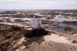
Seymour Tower lies off the south-east coast and is in the Ramsar Wetlands site. Here you’ll be more than 1 miles from the nearest house and literally on the bottom of the sea. But there is no need to bring a mask and snorkel. This area is a unique intertidal zone and is full of amazing marine life and history.
If you do not know much about the tides in this area, join a guided walk with Jersey Walk Adventures or find a person who goes low water fishing in this area. The latter should know their way around though they’ll probably try to avoid showing you their favourite lobster holes.
We allow about 3 hours on our guided walks. This is because we also stop to explore and reveal some of the marine life in this area and also the history of this very special place. There is a lot that you’ll miss if you just head out without a guide. We have been walking this area for over ten years with groups so our guides will reveal places and things you will otherwise miss.
On your left, the dark lines on the beach are the oyster farms. You’ll often see tractors and people busy working on the oyster beds at low tide. Jersey has the largest oyster farms in the British Isles, and you can eat fresh Jersey Oysters at Seymour Inn.
Ahead is a metal rescue tower. The seaweed on the structure shows you how high the tide reaches.
The walk takes you across rocks, sand, mud and through the water. Each habitat has a huge range of marine life. Sandbanks appear as if they should be on a Caribbean island and the water is crystal clear.

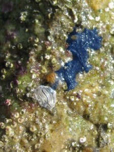
Cobalt blue sponge “terpios fugax”
If you turn a rock over you’ll discover a world of vivid colours and minibeasts but remember to turn the rock back otherwise the creatures will die. All of this intertidal area is an internationally recognised “Ramsar” Wetlands site and has an incredible level of biodiversity. The south-east coastal Ramasar Wetlands site is the largest rocky intertidal area in Europe.
150m south-west of Seymour is a rock with the letter “P” carved on it. It’s quite hard to find and marks the boundary of the ancient feudal land of the Payn family. They were granted the right to gather vraic (seaweed ) following a land dispute in 1747.
The stones in the rock-pools are covered in purple Lithothammion which may explain why the area is called the violet bank.
Seymour Tower was constructed in 1782 following the Battle of Jersey and was used as an early warning station in the event of an attack by the French. There are excellent views from the lower parapet of the entire southeast coast of Jersey. In good visibility, you will see the Normandy coast.
Return at low tide but do not linger. The tide rises very quickly, and the inshore channels closest to shore are the first to fill.

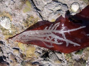
Like lace – Frosted Sea-mat on a Dulse frond
Distance: 3 miles
Time: 2-3 hours depending on how often you stop to explore marine life.
Terrain: Expect to walk over uneven and at times rocky ground and to get wet, perhaps up to your knees.
The walk is only possible when low tide is below 2m. You will find the tide times of high and low water in the Tide Tables or on Jersey Met page. If you are unsure about how the tides work in this area it is best to avoid heading out unless you go with a guide.
Check the weather forecast. This is not a good place to be in if the fog comes down or visibility decreases.
Start 2 hours before the low tide because this allows time to reach Seymour Tower -and get back- without becoming a rescue statistic. Aim to start your return no later than at low tide when you are first venturing out. With more experience, you will learn how to read the water better.
Return at low tide and do not linger. The tide rises very quickly, and the inshore channels closest to shore are the first to fill.
If you do not have much knowledge about the rise and fall of the tides, it is best to join a guided walk with local residents.
Bus route:1
Start from Seymour slip.
Toilets: La Rocque harbour.
Refreshments: Cafe at la Rocque harbour, Seymour Pub.

